The National Centre for Hydro-Meteorological Forecasting said on the afternoon of October 18 that Champi was a powerful storm over the north-western Pacific and the 30th storm to form in the region this year.
Early that afternoon, the storm’s centre was located at about 13.1 degrees north latitude and 142 degrees east longitude, roughly 2,700km east of the Philippines. It had sustained winds at level 16, with gusts above level 17 on Vietnam’s storm intensity scale.
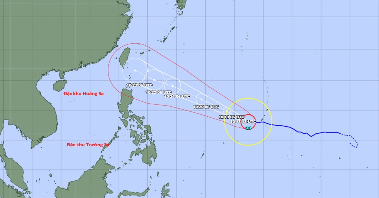
Over the following 24 hours, Champi was forecast to move west-north-west at an average speed of about 20km/h towards Taiwan, maintaining its peak intensity of level 16, with gusts above level 17.
The weather agency expects the storm to maintain this strength for about two more days before gradually weakening from October 21. By then, its sustained winds are forecast to ease to level 15, while gusts could remain above level 17.
When Champi approaches Taiwan, it is expected to have sustained winds of around level 15, with gusts above level 17.

Forecast track of Super Typhoon Champi (Photo: Japan Meteorological Agency).
Based on current forecasts, the centre said Champi was unlikely to enter the East Sea, also known internationally as the South China Sea. The probability of the storm reaching the northeastern part of the sea was estimated at 10-20 per cent, while the chance of it tracking north-west towards Taiwan and China’s coastal provinces was put at 80-90 per cent.
Forecasts from weather agencies in Japan, China and the United States broadly agree that Champi could reach Taiwan around October 23.
Although the storm is unlikely to enter the East Sea, its circulation is expected to strengthen winds over the northern part of the sea in the coming days.
Around October 21, the storm’s western circulation is forecast to affect the northeastern part of the northern East Sea, increasing winds to level 6.
On October 23-24, northeasterly winds over the northern East Sea are expected to strengthen to levels 6-7, with gusts reaching levels 9-10. Waves could reach 3-5 metres, creating rough sea conditions.